Muhammad Ivandrian Farhan

Data Operations & Junior GIS Analyst

Ensuring Data Integrity via Precise QC, Effective Visualizations, and Advanced Geospatial Analysist

Muhammad Ivandrian Farhan

I am a dedicated Geography Education graduate with a strong academic record, holding a GPA of 3.65 on a 4.00 scale. I bring proven expertise in operational leadership and data-driven problem solving, demonstrated through managing large-scale national projects and coordinating vendor performance across multiple regions. Thriving in fast-paced, dynamic environments, I am highly adaptable and committed to continuous professional development. With a strategic mindset and a passion for driving organizational growth, I am eager to contribute effectively to forward-thinking teams and impactful initiatives.

Jakarta (Indonesia)

تواصل
Data Operations & Junior GIS Analyst

Ensuring Data Integrity via Precise QC, Effective Visualizations, and Advanced Geospatial Analysist

Jakarta (Indonesia)

3

المشاريع

3

الخبرة

صورة Muhammad Ivandrian Farhan الشخصية

Projects

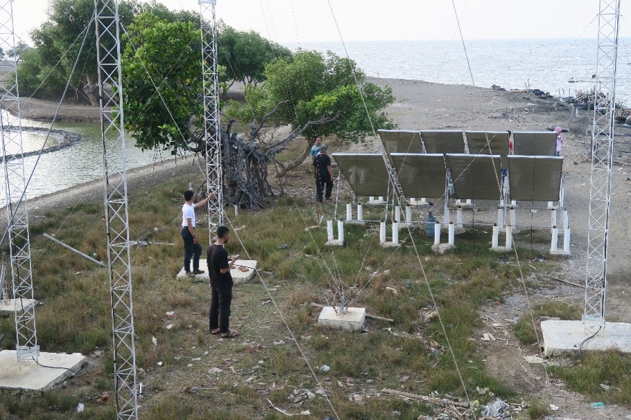
Sea Desalination Project: Hydrometeorological Quality Control

Sea Desalination Project: Hydrometeorological Quality Control

Optimizing ocean energy systems through precise meteorological observation, marine sampling, and geographical analysis of target area delineation

This project focused on harvesting ocean tidal and wave energy to generate sustainable electricity while analyzing environmental variables to ensure long-term equipment maintenance. Deployed as a specialist in climate and environmental factors, my role involved conducting comprehensive geographical studies on the coastal microclimate and weather patterns of the target site. I was responsible for delineating the project's target areas, performing hands-on meteorological observations, and collecting rainwater or air samples to analyze how local weather conditions and seawater characteristics impact the durability of the power-generation instruments.

Meteorological ObservationEquipment Maintenance QCEnvironmental SamplingField Data CollectionDatabase MaintenanceData Geospatial Analysis
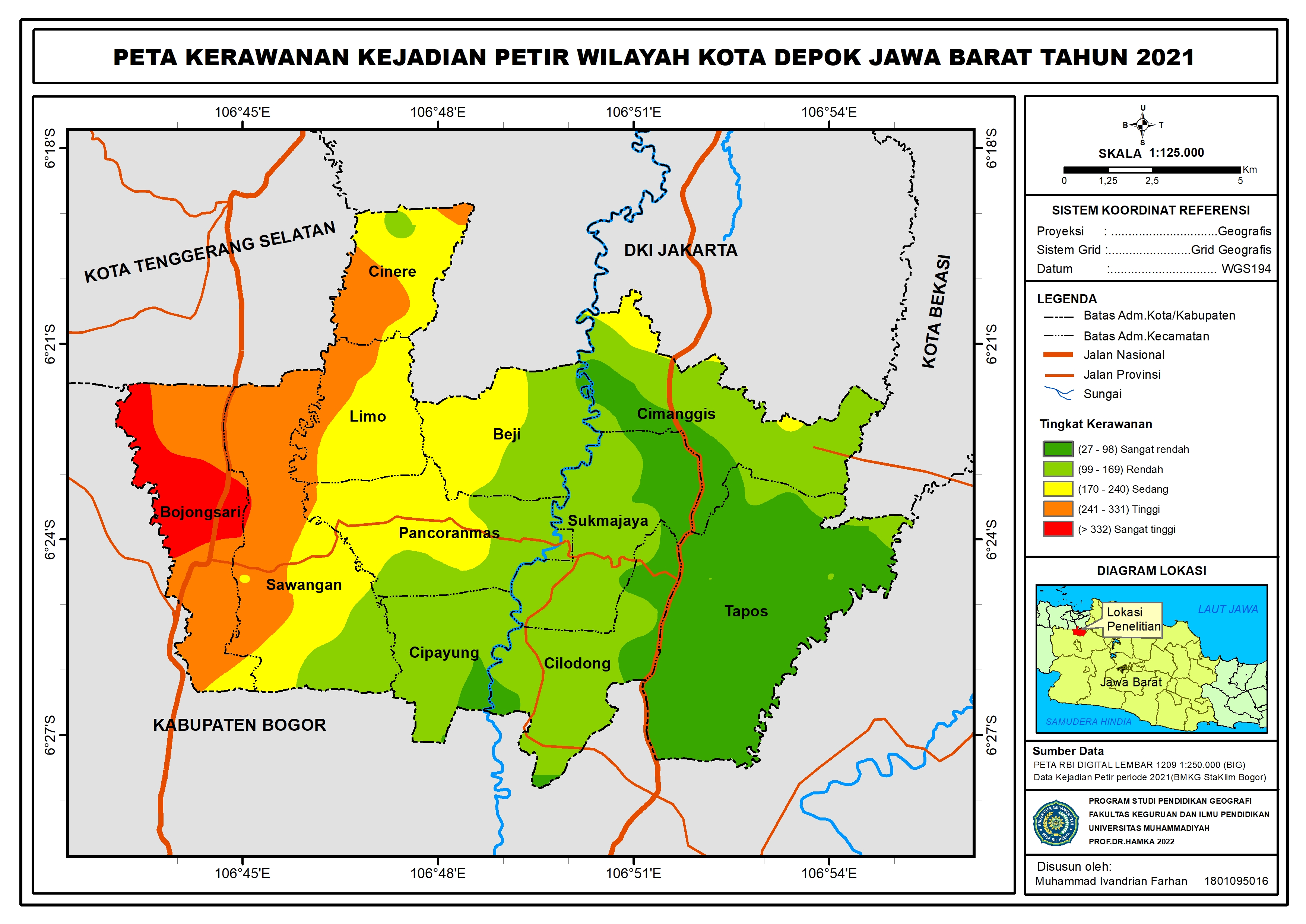
Geospatial and Temporal Modeling of Cloud-to-Ground (CG) Lightning Distribution using ArcGIS

Geospatial and Temporal Modeling of Cloud-to-Ground (CG) Lightning Distribution using ArcGIS

Conducted spatial and temporal analysis utilizing GIS technology to develop risk-mapping data for urban planning and disaster mitigation.

This research presents a descriptive study focused on the spatial and temporal analysis of Cloud-to-Ground (CG) lightning occurrences across Depok City throughout 2021. Due to Depok's unique topography and local convective cloud formations, it records intense lightning activities. The study aims to map lightning-prone areas and assess lightning density across different seasons to provide actionable spatial insights for disaster mitigation and regional decision-making.

Geographic Information System (GIS)ArcGISNexStorm SoftwareLightning Detector (LD-250)Spatial & Temporal Analysis

Environmental Studies in Cigombong Region

This project is a comprehensive geographic and environmental study conducted by a multidisciplinary team in Wates Jaya Village, Cigombong District, Bogor Regency. The study focuses on evaluating local physical geographies to support regional planning. As the team's pedologi lead, the primary focus was analyzing soil characteristics and their environmental implications, while seamlessly backing up the team's spatial mapping (GIS) and hydrological frameworks to ensure an integrated environmental database.

Pedological & Soil Classification AnalysisGIS MappingArcGIS / QGISHydrological ModelingTeam CollaborationCross-functional Support

Experience

Operations Support & Geospatial Data Analyst– Map Ops ID Division in Regional Support Team (2024) and Places Team (2025)

PT. Grab Teknologi Indonesia

يناير 2024 — يناير 2025 · 1 سنة 1 شهر
دوام كاملهجين

Served as Operations Support within the Map Ops ID Division, the core team responsible for maintaining and optimizing the geospatial mapping system for the Grab application across Indonesia. Transitioned from the Regional Support (Vendor) Team in 2024 to the Places Team in 2025. This dual-tenure involved leading large-scale field data collections, managing multi-regional vendor operations, and driving automation by combining basic SQL, Google Apps Script, Spreadsheet prototypes, and Artificial Intelligence (AI) to accelerate data quality control workflows.

  • Coordinating external vendors, cross-regional teams, and local field surveyors to execute large-scale mapping and data collection projects.
  • Performing high-volume data entry, database maintenance, and strict quality control (QC) to ensure 100% accurate Points of Interest (POI) on maps.
  • Developing interactive Looker Studio dashboards and implementing automated workflows using basic SQL, Google Apps Script, and AI to accelerate data validation.
Data Visualization (Looker Studio/Excel)Basic SQL, Google Apps Script, Artificial Intelligence (AI) Prompting (Database & Automation)Google Workspace (Spreadsheets, Docs, etc.), SlackSpatial Data EntryQuality Control (QC) & ValidationVendor & Project Management

Successfully hit the national mapping vendor target

100% QC accuracy on 240,000 field collection datasets with PT Efort across 8 cities

Expanded localized map coverage and boosted driver engagement metrics

Collected and verified over 20,000 new driver-sourced POI entries in East Java

Achieved the target within the strict deadline through automated data filtering

Built an AI & Apps Script prototype to QC 400,000 purchased database rows

Significantly enhanced the reliability of the Grab Indonesia navigation ecosystem

Managed and maintained over 600,000 total Points of Interest (POI) points over 2 years.

Junior Data Analyst & Project Finance Administrator – Weather Modification Technology Project in the KPC-PAMA mining area

PT. Reka Cuaca Indonesia

أبريل 2023 — يوليو 2023 · 4 أشهرKalimantan Timur
دوام كاملمن الموقع

Deployed as part of the Weather Modification Technology (TSSA) project at the PT KPC and PT PAMA mining sectors, this initiative aimed to mitigate weather-induced operational downtime and optimize annual mining exploration targets. The project utilized a data-driven approach by deploying Cloud Seeding Technology (SSA) across 12 strategic target locations, integrated with Automatic Weather Stations (AWS) to monitor real-time wind patterns and precipitation. Serving a dual role, I managed end-to-end operational data workflows while concurrently overseeing the project's financial administration and operational cost controls.

  • Performed daily data entry and rigorous quality control on meteorological variables from AWS to ensure data integrity for cloud seeding efficiency.Ensured 100% data accuracy and verified a 20% average rainfall reduction to maximize operational uptime
  • Managed project expenses, invoicing, and tracked operational area expansion from 4,600 Ha to 6,658 HaMaintained precise budget control in this project
Data Entry & Quality Control (QC)Data Visualization & ReportingMicrosoft Excel (Financial Tracking & Invoicing)Climate, Meteorological & Hydrological ( Monitoring)

Minimized weather delays in the PT PAMA area

17% Intensity, 22% Duration, and 19% Frequency reduction

Maximized heavy equipment uptime in the PT KPC area

23% Intensity, 25% Duration, and 20% Frequency reduction

Proved the overall effectiveness of the cloud seeding system

Project average of 20% Intensity, 19% Duration, and 18% Frequency reduction

Justified the strategic addition of new cloud seeding units

Tracked area expansion from 4,600 Ha to 6,658 Ha (44.7% increase)

Staff Intern Observation and Laboratory assistant

Badan Meteorologi Klimatologi dan Geofisika/Stasiun Klimatologi Jawa Barat

أكتوبر 2021 — ديسمبر 2021 · 3 أشهر
دوام كاملمن الموقع

During my internship at BMKG Climatology Station West Java, I served as a Staff Intern Observation and Laboratory Assistant, where I was responsible for ensuring the accuracy and continuity of regional climate data. Working within a structured shift system, I performed foundational data processing and entry for daily climate observations. Additionally, I supported environmental monitoring efforts by assisting in the chemical and physical analysis of air and rainwater quality across the Bogor region, ensuring strict data verification and quality control standards in both the field and the laboratory.

  • Responsible for climatology data and basic data processing while operating shift system for climate data observation.
  • Assisted in analyzing air and rainwater quality in Bogor area, West Java.
Basic level Climate and Meteorological Data ProcessingObservation Equipment Operation & MaintenanceLaboratory Instrument Calibration & Quality Control (QC)Air & Rainwater Quality Sampling & Chemical AnalysisShift-Based Operational Data Entry & Logging

Skills

Project Lifecycle ManagementCross-functional CoordinationMentoring & SupportCommunity EngagementReal-time Reporting (Looker Studio)Data VisualizationQuality ControlSpatial AnalysisMicrosoft Office Suite (Excel, PowerPoint, Word)Google Cloud ToolsOperational ReadinessShift-based working hours adaptabilityArcGISQGISSpatial Quality ControlFinancial Administration

Education

Bachelor of Education (S.Pd.)

Muhammadiyah Prof. Dr. Hamka University

سبتمبر 2018 - أغسطس 2022Jakarta
درجة

التركيز: Geography Education

المعدل: 3.65 / 4.00

  • Graduated with a distinction GPA of 3.65/4.00
  • Research & Academic Projects: Actively built and contributed to various geographic research projects alongside university lecturers.
  • HMPG (Himpunan Mahasiswa Pendidikan Geografi): Served as a Staff member in the Academic & Scientific Department, regularly organizing monthly educational seminars. Spearheaded the flagship national event, “Seminar Nasional Geography Education and Call for Paper 2020”, serving as the Chief Executive to manage the entire administrative, budgeting, and logistical execut
  • IMAHAGI (Ikatan Mahasiswa Geografi Indonesia): Served as a Staff member in the Communication and Public Relations Department as a Media Content Specialist.

المقررات

Spatial Data AnalysisGeographic Information Systems (GIS)ClimatologyHydrologymeteorologyQuantitative Research Methods

الأطروحة / مشروع التخرج

Spatial and Temporal Analysis of Lightning Occurrences in Depok City in 2021

Conducted a comprehensive geospatial data analysis tracking the spatial distribution and temporal patterns of lightning strikes across Depok City using GIS tools. Processed large atmospheric datasets to identify high-risk zones, seasonal trends, and climatological correlations, translating raw environmental data into actionable spatial maps and statistical insights.

Social Humaniora

Suluh Jakarta Highschool

يناير 2015 - يناير 2018
أخرى
  • Bronze Medal in Karate Bekasi Open 2016; Gold Medal Iyos Cup 2017.

التواصل

دعنا نتواصل. اختر أسرع طريقة للوصول إليّ.
البريد الإلكتروني

ivandrianforwork@gmail.com

أسرع رد عبر البريد الإلكتروني.

راسلني
الهاتف

+62 8 7793743141

اتصالواتساب

Muhammad Ivandrian Farhan

Ensuring Data Integrity via Precise QC, Effective Visualizations, and Advanced Geospatial Analysist

روابط سريعة

ملخص التواصل

البريد الإلكتروني: ivandrianforwork@gmail.com

الهاتف: +62 8 7793743141

© 2026 Muhammad Ivandrian Farhan. جميع الحقوق محفوظة.